|
Home : Quarterly Archives : Volume 42 |
||||||||||||
Tredyffrin Easttown Historical Society |
||||||||||||
|
Source: Summer 2005 Volume 42 Number 3, Pages 95–103 GREAT VALLEY AREA LIMESTONE QUARRIES
[Editor's note – There were three major areas of limestone quarrying in the Great Valley: Howellville, Cedar Hollow, and Valley Forge/Port Kennedy. This article is about the Howellville quarries. The quarries at Cedar Hollow and Valley Forge/Port Kennedy will be covered in future issues.]
The Great Valley was once covered with water. Over long geologic periods corals and shells in this water eventually became the sedimentary rock known as limestone. Limestone is easily dissolved by water and eventually runoff surface water often causes cracks in large deposits of limestone. These may continue to enlarge and may form sinkholes, chasms, or caves. Sometimes the roofs of these may collapse and form steep sided ravines or dry valleys. When men or companies move into these ravines or valleys and start taking out the limestone these areas are called quarries. Limestone is used as a building material. Lime, also called quicklime, is a by-product of limestone and is obtained by burning limestone, wood, and coal in lime kilns. The result is chunks of white powdery material which are then ground to a fine powder. Lime has many uses. It is spread on acidic soil to neutralize it. It is used to hold the materials in cement mortar and plaster together and to make whitewash. Limestone with a less superior quality of lime is used in a crushed form for building roads, constructing buildings, and for railroad ties ballast. Limestone from Great Valley quarries was used in building many local roads and buildings including the county courthouse in West Chester and Waynesborough, the home of General Anthony Wayne. Within the Howellville area there were at least 7 different quarries and 4 separate quarrying operations: Dyer Quarry/Lavino Quarry/Daylesford Lake Community, Johnson Quarry/Westlakes Corporate Park, Rennyson, and Centerville. The busiest period of quarry operations in Howellville was between the mid-1800s and the Depression years. The Dyer and Johnson quarries were the most profitable. Major changes were made to the original 3 roads that formed the intersection in Howellville—Swedesford Road, Howellville Road, and old Route 202, also known as Bear Hill Road—between 1967 and 1971 when present day Route 202 was built and old Route 202 became Route 252. Most of the buildings in Howellville were torn down and other roads in the area were done away with or rerouted. Today it is quite difficult to determine just where some of the quarries and quarry operations shown on the old atlases were. Another factor making it difficult to distinguish between all the different Howellville quarries is that in the past most of the people who lived there and the people who wrote about them did so collectively, rarely stating specifically which quarry or quarrying operation they were talking about. It is probable the quarries in Howellville were used on a non-commercial basis before the Revolutionary War by local farmers who burned limestone in their own kilns and spread the resulting lime on their fields to improve the soil.
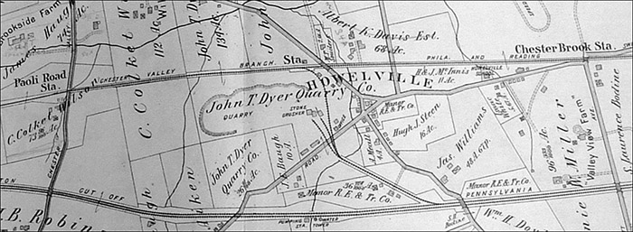
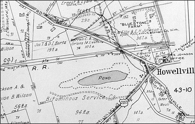
The opening of the Chester Valley Railroad in 1853 meant the quarries in Howellville could begin to think about operating as businesses as they now had the means to ship their products into Philadelphia and points beyond. The 1873 Witmer atlas, the first substantial atlas of this area, shows the various stations of the Chester Valley Railroad and an area of lime kilns in the quarry area, but does not show any operating quarries. However, by the time the 1883 Breou atlas was published, William Johnson and Hugh Steen, a large landholder in the area, are shown as the operators of Howellville's largest quarry at that time. It was located between the south side of Swedesford Road and the west side of old Route 202, now present day Route 252, also called Bear Hill Road. Stone crushing, rather than the production of lime, was the major activity here. With increased business resulting from the railroad new workers were needed. The first to come were Italians, the most numerous and prosperous of all the quarry workers in Howellville. Many of their families still live in the 5 houses standing today on the east side of Howellville Road where it meets Route 252. In the middle of the nineteenth century, Italian quarry worker families also rented other older houses in the immediate area. The Breou atlas also shows that by 1883 there was a rail spur north to the Howellville Station—located between the Paoli Road and Rennyson (later called Chesterbrook) stations—of the Chester Valley branch of the Philadelphia and Reading Railway, formerly the Chester Valley Railroad. Later there was a rail spur south to the Trenton Cut-Off. In 1883 Johnson and Steen had a $70,000 contract to build a 2-mile road between Germantown and Chestnut Hill in Philadelphia. The June 29, 1883 Daily Local News describes Howellville as a busy place: Howellville, Tredyffrin township, this county, presents a lively appearance and has become quite an extensive business place. Messrs. Steen & Johnson have just erected another stone crusher, which now makes two they have in operation at that place. They are breaking an immense amount of stone, which are being used in the construction of Telford road they are building near Chestnut Hill. They are shipping every day five eight-wheel car loads of broken stone to that point. James Riley, who removed there last spring is also stirring matters up. He is burning lime and shipping large quantities of limestone and white marble to Bechtelville furnace, Bucks county, and other lime works. Mr. Riley not only ships by rail, but he had besides two four-horse teams constantly on the road hauling lime for building and land purposes. Riley had financial troubles and by 1888 Sim & Kinnear had taken over his quarries, now called the Howellville Quarries. On April 22, 1889 Daily Local News notice states: The Howellville stone quarries are booming. There are at least 25 men employed daily where but a few weeks ago all was quiet and gloomy, for the stone crusher was stopped and the ring of the drill was heard not in the little village, for the sheriff had been there. The new firm that owns the quarries (Messrs. Sim & Kinnear) are turning out from 50 to 110 tons of broken and crushed Blue lime stone, much of which is used in walks and drives along the North Penn Railroad around gentlemen's places at Germantown and elsewhere. It is crushed from fine dust to 1½ and 3 inches. Last month the firm shipped 120 tons. Recently one blast, prepared by a steam drill, threw up 150 tons. Quite a blast. 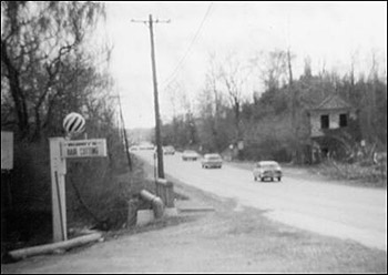
This 1970 photograph shows old Route 202 looking south from the intersection with Howellville Road. The abandoned Dyer quarry office is on the right and the Howellville Headquarters barber shop is on the left. Photograph by Dorothy Reed. Tredyffrin Easttown Historical Society. Mueller's 1912 atlas, below, shows two tracts, one of 134 acres and another of 26 acres, for this quarry, now stated as owned by the John T. Dyer Quarry Co. This atlas also shows the rail spur up to the Chester Valley branch of the Philadelphia and Reading Railway and the rail spur down to the Trenton Cut-Off. The 1926 Bromley atlas continues to show the John T. Dyer Quarry Co. as the owner. The 1933 Franklin Survey property atlas states the quarry is owned by E. J. Lavino Co., a shipping company, owner of many Howelville houses. The north and south rail spur lines are no longer present. The Dyer/Lavino quarry office along old Route 202 could be seen as late as 1970.
A. H. Mueller 1912 atlas, Plate 7, Tredyffrin Township.
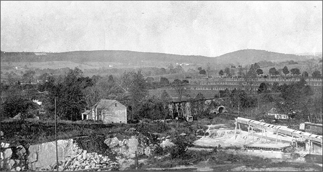
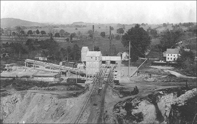
The large group of buildings in the middle of the lower photograph is the stone crusher at the Dyer quarry. The top and bottom photographs can be aligned end to end for a panoramic view of this area. The elevated track of the Chester Valley Railroad where it bridges Swedesford Road is seen near the middle of the top photograph. The rectangular building at the right edge of the bottom photograph is thought to be the second Howellville Inn on Swedesford Road that was torn down in 1921. The quarry can be seen along the bottom edge of both photographs. Photographs courtesy of Sue Andrews. The quarry had a large bell-shaped stone crusher—built sometime before 1897 —that ground the limestone and had to be kept well oiled. In the 1920s a big steel drum with rotating steel balls that pulverized the ground limestone to a powder was built next to the crusher. It is said that when the limestone gravel was added it turned and shook like a huge washing machine and was very loud. The powder was bagged and sold to local farmers. When the steel balls wore out and became too small they were used by the quarry workers to play bocce in the middle of Swedesford Road. Mert Lemma, an Italian American, and Bobby “Mex” Barajas, of Mexican descent and the owner of the Howellville Headquarters barbershop at the intersection of Howellville Road and Route 252, are two local residents whose families worked at this quarry and who remember what it was like in Howellville at that time. Lemma remembers mules pulling big iron carts full of pieces of limestone to an area where they were hooked up to heavy cables that pulled them up to the top of the crusher where the limestone pieces were dumped in. Barajas remembers swimming and sledding in the quarry and that there were rock blasting accidents, people falling through the ice, drownings, and suspicious suicides. Shamrock Thornton was the black engineer who ran the “switcher”—a steam engine—on the spur lines between the quarry and the Chester Valley Railroad and the Trenton Cut-off. Many considered this the “best” job at the quarry. Both Lemma and Barajas remember there was no discord between the various groups of quarry workers. 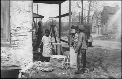
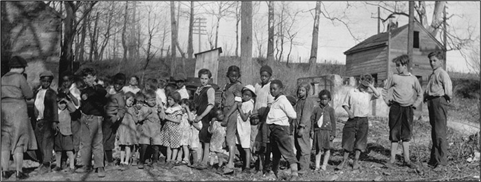
Children participating in the 1934 cleanup of Howellville by the Valley Forge branch of the Farm and Garden Club under the direction of Frances Ligget. Whitewash was supplied by the Warner Company of Cedar Hollow. W. E. Johnson's trucks hauled away 14 loads of debris in which several Revolutionary War cannonballs were found. Reminiscences, Great Valley, Chester County, Pennsylvania, Valley Forge Section (Part two), Frances H. Ligget. June 1965. Courtesy Paoli Library. 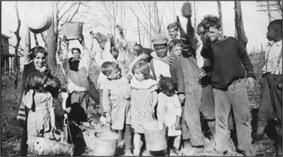  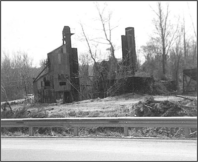
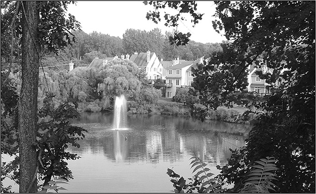
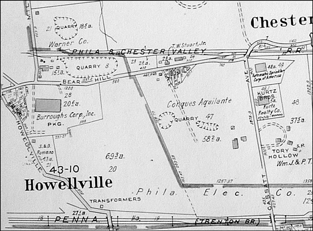
Remains of the Howellville stone crushers in April 1970. Photograph by Dorothy Reed. Tredyffrin Easttown Historical Society. The Depression of the 1930s hit Howellville hard and by now most of the original Italian workers had been replaced by Mexicans. In 1934 Frances Ligget and the Valley Forge branch of the Farm and Garden Club had a clean-up project there to help the unemployed quarry workers and their families. Debris was cleared, buildings were whitewashed, and families were given free seeds, medical assistance, a nursery school, and classes in sewing, knitting, and cooking. Weaving was taught by Lettie Esherick, wife of local artist Wharton Esherick. As early as the 1880s the quarries had seepage problems. They were always filling with water and had to be constantly pumped out at the same time that quarrying operations were going on. In the late 1930s all the electricity at this quarry was knocked out during a major thunderstorm. The water pumps stopped and water quickly filled the quarry. By this time the quarry couldn't compete with other large quarries so it was abandoned and left to fill with water. Plate 2 (Part of Tredyffrin Township) and plate 4 (Tredyffrin and East Whiteland Township) of the 1950 Franklin Survey atlas show the old Dyer quarry as part of a 109-acre tract owned by Harry Radbill, whose Bituminous Company manufactured asphalt in the quarry area. It is not known when the quarry took the name of Howellville Quarries, Inc. Plate 12 (Tredyffrin and East Whiteland Townships) of the 1963 Franklin Survey atlas shows this quarry as a pond. By 1969 bulldozers from Bituminous Services, Inc. of West Chester were at the quarry pushing the high hills of waste material from earlier operations that now surrounded the quarry back into it. This never completely filled in the hole. The Daylesford Lake community of houses is now in this location and if you drive into this development you can see the remains of the quarry in the middle. This remnant of the lake in among these homes is all that remains of the largest of all the Howellville quarries.
Daylesford Lake. Photograph by Joyce A. Post, July 2005.
Two additional quarries in the Howellville area between present day Routes 252 and 202 and Swedesford Road and Chesterbrook Boulevard, were owned in the early 1700s by Llewellyn David (the name was later changed to Davis), the original settler of Howellville, and remained in the Davis family for 2 centuries. When the Chester Valley Railroad tracks were built they ran between these two quarries. Today, shortly after entering the gate at Westlakes Drive off of Route 252 heading south, you can see a section of the right-of-way of these former tracks to your left and right. In 1917 a last descendant of the Davis family sold the quarries to Samuel and Emily Given. Both of Sam's arms were blown off while he was working the quarries. His wife, Emily, did the bookkeeping and chauffeured Sam while he continued to run these quarries, which specialized in crushed limestone. By 1926 Samuel Givens had sold these quarries to W. Ellis Johnson. Johnson called his land and area Blue Stone Farm because the limestone here was called “blue stone.”
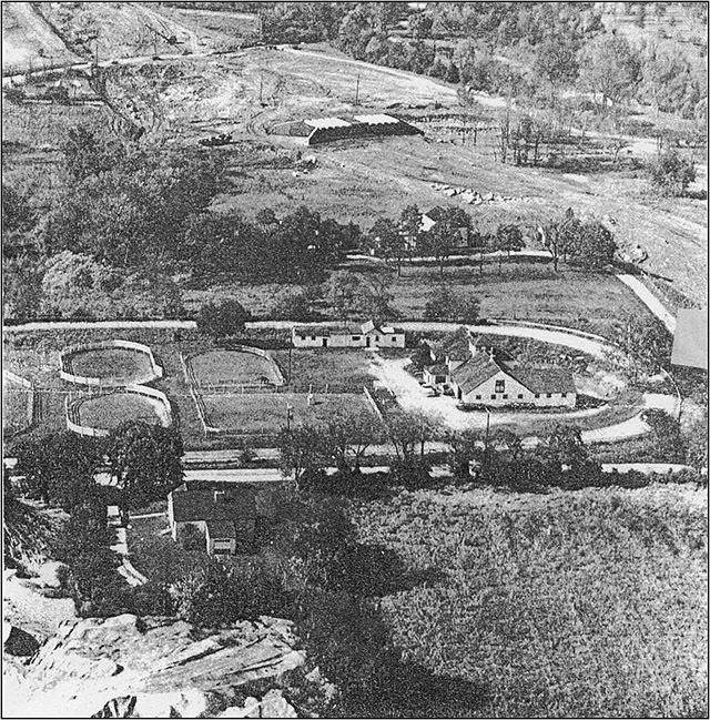
The oval track and buildings at Blue Stone Farm, on the upper map is across Mill Road, no longer in existence here, from the two Johnson quarries on each side of the Chester Valley Railroad tracks in the upper left corner of the bottom map. Franklin Survey 1963 atlas, Plate 3, Part of Tredyffrin Township.
There was an oval where Johnson raised and trained racing horses. This was mainly a concrete producing operation.
The oval race track and buildings of Blue Stone Farm. North is to the right and Mill Road, no longer in existence in this location, crosses from left to right below the oval. The edge of the northern, smaller Johnson quarry is in the lower left corner. Courtesy of Jane Tiffany and Sue Andrews. Johnson used trucks that were chain driven, had no front axles, and had gas headlamps to bring loads of limestone up the inclines of the quarry. The chains would break and the loads of limestone would be lost. 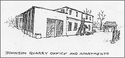
The Johnson quarry office, scales, and apartments were on the same side of Mill Road as the quarry. Courtesy of Sue Andrews, artist. A June 5, 1947 notice in the Daily Local News advertises that W. E. Johnson of Paoli, Pa. is now operating a “Ready mixed concrete plant using Howellville blue stone.” There was also a W. E. Johnson Trucking Company at this location that did local hauling until around 1950. The 1950 Franklin Survey atlas continues to list W. Ellis Johnson as the owner of these quarries. A major change came in 1957. A February 16, 1957 Daily Local News business notice states: W. E. Johnson, Inc., a stone quarry at Paoli, was purchased yesterday by Warner Co. The report did not disclose the price. Warner president, John Curtin, Jr. is quoted: “For several years this company has operated a stone quarry and a fleet of trucks for mixing and delivering concrete. The shipping area for both stone aggregates and concrete embraces the entire Main Line and Paoli area and will enable Warner Co. to benefit from construction work in a territory not now served by present facilities. Plate 3 (Part of Tredyffrin Township) of the 1963 Franklin Survey atlas shows that the larger quarry of 18 acres on the north side of the railroad tracks is owned by the Warner Co. No owner is given for the smaller quarry of 8 acres to the south. Blue Stone Farm burned in 1974. 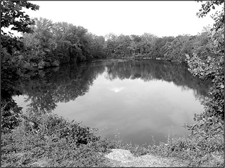
The larger Johnson quarry as viewed from inside the Westlakes office park south of the Chester Valley Railroad right-of way. Photograph by Joyce A. Post, July 2005. These Johnson quarries are now the site of the Westlakes office park. When you drive along Route 252 today going south just past the intersection where Chesterbrook Boulevard comes in from the right you can see a large water-filled quarry on your right. This quarry may also be viewed from inside the Westlakes complex near the south side of the old Chester Valley Railroad right-of-way. The second Johnson quarry is behind the building at 1055 Westlakes Drive and may be seen from the 2d floor balcony of this building overlooking the atrium in the lobby. The other, more visible, body of water at the Route 252 and Chesterbrook Boulevard intersection was not a quarry.
A smaller quarry was located southeast of the Johnson quarries. It was opened in 1869 when William Rennyson came to Howellville and was worked until about 1885. There was a rail spur going north to the Rennyson Station on the Chester Valley Railroad. Burns (pp. 38-39) states that about 60 men, mostly Irish, were employed here and 8 stone workers' houses had been built in pairs in a row along Swedesford Road. This quarry was mostly a lime producing operation with 8 kilns. The workers bagged the lime by hand and their highest pay was $.60 an hour. In the 1880s, Rennyson and a group of entrepreneurs bottled natural soda water produced by the high amount of lime in the water and sold it as “Tredyffrin Water.” 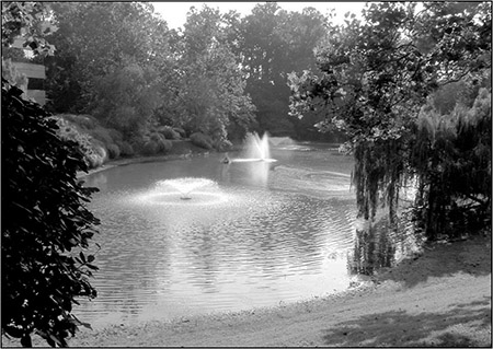
Rennyson quarry. Photograph by Joyce A. Post, July 2005. The 1950 Franklin Survey atlas shows Conques Aquilante as the owner of the land where this quarry and another smaller quarry were located. Bobby “Mex” Barajas remembers fishing for minnows in this quarry and selling them to local fishermen. Today this quarry can be seen in front of an office building on the south side of Cassatt Road after turning off Route 252 into the Berwyn Park entrance.
As early as 1879 William Johnson was operating a quarry in this location to the east of Howellville. A June 19, 1882 note in the Daily Local News says that: William Johnson has had a new stone crusher erected at his stone quarries at Centerville, Tredyffrin township. The one he had formerly in use at that place he had removed to Newtown, Delaware county, which is kept busy at work. The January 23, 1882 Daily Local News has a notice with the heading “Polanders in Howellville”: William Johnson has within a few days past employed 17 Polanders to work in his lime stone quarries, at Howellville, Chester county. These Polanders have recently arrived in the country and attract considerable attention in the neighborhood by their quaint looking dress, manners and customs. Mr. Johnson has now about 25 men employed in his quarries getting out stone for lime burning, and also to crush stone for building the macademized road through the stock farm of A. J. Cassatt, near by, for which he has the contract. He is also crushing stone for the township of Tredyffrin, which is being used on some of its roads. A Daily Local News story of December 6, 1883 describes how the stone crusher at this quarry was broken: One of W. Johnson's Hungarians at Howellville, Chester Valley, the other day let a large hammer fall into the stone crusher, which was then in motion. The result was a terrible sound like a general shaking up of the earth. The crusher was badly broken. The Hungarian was scared almost to death, by the report.
Andrews, Sue. “Howellville.” Tredyffrin Easttown History Club Quarterly, Vol. 39, No. 3 (July 2002). pp. 75-103. Atlas of Chester Co., Pennsylvania From Actual Surveys by H. G. Bridgens, A. R . Witmer and others. Safe Harbor, Pa.: A. R. Witmer, 1873. Atlas of Properties on Main Line Pennsylvania Railroad From Devon to Downingtown and West Chester Embracing Boroughs of Downingtown, Malvern, and West Chester, and Easttown, East Bradford, East Caln, East Goshen, East Whiteland, Newtown, Thornbury, Tredyffrin, Upper Merion, Westtown, West Goshen, West Whiteland, and Willistown Townships. Compiled From Actual Surveys, Official Records and Private Plans by J. M. Lathrop and St. Julian Ogier, Civil Engineers. Under the Direct Supervision and Management of A. H. Mueller, Publisher. Philadelphia: A. H. Mueller, 1912. Atlas of Properties on Main Line Pennsylvania Railroad From Overbrook to Paoli. From Actual Surveys and Official Plans by George W. and Walter S. Bromley, Civil Engineers. Philadelphia: G. W. Bromley and Co., 1926. Breou's Official Series of Farm Maps, Chester County, Pennsylvania. Compiled, Drawn and Published from Personal Examinations and Surveys. Philadelphia: W. H. Kirk & Co., 1883. Burns, Franklin L. “The Stone Quarries, Ore Mines and Sand Pits of Easttown and Tredyffrin.” Tredyffrin Easttown History Club Quarterly, Vol. 7, No. 2 (December 1949). pp. 33-41. Dorchester, Jane. “A Village off Main Line's Beaten Path.” Sunday Local News (October 25, 1987). p. A10. “Farewell, Quarry Swimming Hole! Howellville Lake is Being Filled In.” Suburban and Wayne Times (December 11, 1969). p. 2. Halpin, Alyse S. “The Howellville Quarries.” Main Line Life, History (August 27, 1998). p. 7. Morrison, Harlan. “Some Thoughts on Limestone and Lime Kilns in Chester Valley.” Tredyffrin Easttown History Club Quarterly, Vol. 37, No. 1 (January 1999). p. 3-8. Property Atlas of Chester County, Penna. Complete in Three Volumes. Volume One Including the Boroughs of Downingtown, Malvern, and West Chester, the Townships of Birmingham, Charlestown, Easttown, East Bradford, East Caln, East Goshen, East Whiteland, Schuylkill, Thornbury, Tredyffrin, Westtown, West Goshen, West Whiteland, Willistown, also Newtown Township in Delaware County. Compiled From Official Records, Private Plans and Actual Surveys By and Under the Supervision of the Franklin Survey Company ... Philadelphia: Franklin Survey Company, 1933. Property Atlas of the Main Line, Penna. Volume Two, Chester County Including the Boroughs of Malvern and Phoenixville, the Townships of Charlestown, Easttown, East Goshen, East Whiteland, Schuylkill, Tredyffrin, West Goshen, West Whiteland, Willistown, also Newtown Township in Delaware County. From Official Records, Private Plans and Actual Surveys. Compiled Under the Direction of and Published, Sold and Revised Exclusively by Franklin Survey Company ... Philadelphia: Franklin Survey Company, 1950. Property Atlas of the Main Line, Penna. Volume Two Embracing the following municipalities in Chester County: Townships of Tredyffrin, Easttown, Willistown, East & West Whiteland, East & West Goshen and the Borough of Malvern. From Official Records, Private Plans and Actual Surveys. Compiled Under the Direction of and Published, Sold And Revised Exclusively by Franklin Survey Company ... Philadelphia: Franklin Survey Company, 1963. Joyce A. Post is interested in early industries and businesses in this area. She has previously written about the Burroughs Research Center in Paoli. She may be contacted at 244 Vincent Road, Paoli, PA 19301.
Quarry workers' children at the 1934 Howellville cleanup. Reminiscences... by Frances H. Ligget. 1965. |
||||||||||||