|
Home : Quarterly Archives : Volume 2 |
Tredyffrin Easttown Historical Society |
|
Source: October 1939 Volume 2 Number 4, Pages 102–103 Forest Primeval August 5 - 7, 1939 Leaving Berwyn about 7:10 Saturday, the caravan consisted of three cars with six members and three guests. Our first objective was the Allegheny National Forest. We arrived at Harrisburg, via Lancaster, a little after ten, and made our first step for refreshments beside the Susquehanna. Then along the beautiful river drive to Clark's Ferry Bridge, and up the Juniata over Route 322, through Mifflintown and Lewistown. Several miles beyond, a wayside park in the making, beside a mountain stream, tempted us to stop for lunch, and the ladies unpacked a marvelous store of eatables. On past Potter's Mill, State College, Clearfield and DuBois (pause for refreshments. Our leader would sooner lose the campaign than see our army hunger!) Having passed over Jack's and Bald Eagle mountains, we next ascended to the plateau of the Alleghenies, a region of wondrous wild beauty, where the headwaters of the Clarion and Allegheny rivers rise, a land white with fields of blossoming buckwheat where it was not dark with forest, and onward to Kane on 219, where we dined. Near here we had entered the National Forest in its experimental stage, only to learn that the big timber was at Cook's, which meant a 47 mile drive on 68 through the forest at sunset, but what a gorgeous sunset in the wilds! We arrived at Cook's State Forest about 9:30, only to learn that the one small hotel and all the cabins were filled. However, the telephone secured us accommodations at Walley's camp, some miles beyond.
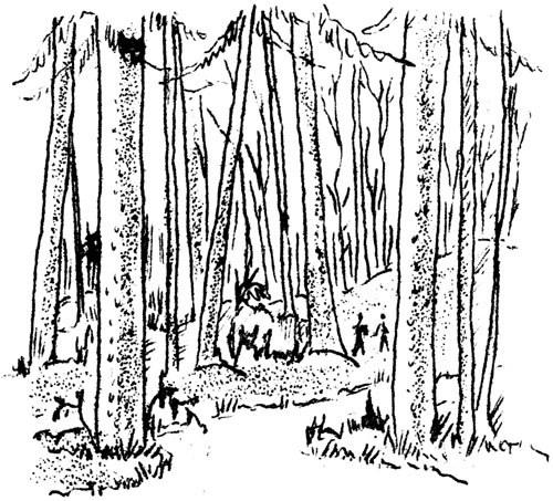
We were up at 7:30, and after breakfasting at Cook's Hotel, spent a most delightful portion of the morning hiking over the Longfellow Trail and through a part of the only considerable strand of original white pine in the state, the Cook Forest State Park of over 6,000 acres. Trees estimated from 200 to 500 years old and up to 200 feet tall, branchless until near the umbrella-like tops. Titanic! As we ascended the trail, our eyes fixed upon the gigantic pines and hemlocks, we unconsciously lowered our voices, comparative pygmies that we were, for centuries looked down upon us. We regretted that we had not time to traverse the other trails. Returning to Kane, we followed Route 6 to Mt. Jewett, to the left from Port Allegheny to Larabee, 446 to Portville N.Y., 17 to Corning - a stricken region, rainless or nearly so for months, leaving dry creek beds and parched fields. Near Wellsville there were numerous small oil wells.
The second picnic lunch was held somewhere near the state line. At Corning we took 414 for Watkins' Glen and we viewed the beautiful Seneca Lake from the heights arriving in the town late in the afternoon of the 6th. Here we secured pleasant quarters. We had a most delightful boat ride on Lake Seneca in the evening. The skipper pointed out the salt works, wells sunk 3,000 feet to a bed of pure salt, the painted rocks, etc. The hour's trip over the 650 foot deep lake so fascinated the majority of the party, that they went out the second time. Monday morning most of the group walked the mile and a half length of the Glen, ascending the 834 stone steps and descending by taxi. Ten o'clock found all ready to leave by 14 to Horseheads, 17 to Elmira, and Athens, Pennsylvania. At the Tioga Point Museum, in Athens, Dr. Elsie Murray bade us welcome and gave us a private view of their wonderful collection of Indian relics. It is sufficient to state that this museum has the relics of some twenty-five tribes inhabiting Tioga Point at different periods, complicating its archaeology with layer on layer of conflicting evidence. We noticed the New England influence in the prim architecture and landscaping, especially the elm-lined streets of Athens. Then we realized that this part of the state was claimed and settled by the Connecticut Yankees. We had passed from the Susquehanna watershed to that of the Ohio Valley, then the St. Lawrence and were again in the Susquehanna watershed. On the 1,000 acres flat is what is known as the "Indian Arrow." The notch of the arrow is at Athens, where the Susquehanna and Chemung Rivers approach as though intent upon uniting, but sweeping apart abruptly, actually join two miles below, forming the arrow point. This was the southern gateway of the Iroquois to their hunting ground in the valley of the Wyoming. Also from here they issued on their war expeditions against southern tribes and later against the white settlers. Passing through Towanda and Wyalusing, we became involved in the streets of Scranton, but found 611, which brought us down to the Pocono region. It may be of interest to note that our last day's journey followed in reverse Sullivan's route from the Poconos to the Finger Lakes in his punitive expedition during the summer of 1779 against the Six Nations. The battleground of Newtown appeared well marked. Space will not permit enlargement on Sullivan's campaign. We passed through Wind Gap, Nazareth, Bethlehem, and had our last dinner together at Trainer's, near Quakertown - a typical Pennsylvania Dutch dinner. We arrived home about 9:30 p. m., having covered some 8&8 (sic) miles by automobile and several more by foot. It was a most interesting mountain tour. |