|
Home : Quarterly Archives : Volume 27 |
Tredyffrin Easttown Historical Society |
|
Source: January 1989 Volume 27 Number 1, Pages 29–37 Archaeological Investigations at Conway's Brigade, Valley Forge Valley Forge National Historical Park contains the major elements of the winter encampment of 1777-1778 of the Continental Army. The park is located along the banks of the Schuylkill River, approximately 12 miles west of the Philadelphia city line. The primary cultural resources within the park are the archaeological remains of the brigade encampments. These are located on sandstone terraces surrounding a central limestone valley that forms the core of the park. From December 19, 1777 to June 19, 1778, approximately 11,000 soldiers, accompanied by an unknown number of women and children, lived in hastily constructed log huts along these terraces. During the winter months the inhabitants of the camp suffered from the harsh weather and the collapse of the army's supply system, leaving the legacy of the "naked and starving" army that emerged from Valley Forge to found the new nation. Unlike other winter encampments of the Revolutionary War, historic documents provide little information on the layout of the camp. The earliest accepted map was probably drawn by the army's Chief Engineer, Louis Du-Portail; it identifies the location of general features, including the fortifications, headquarters, and brigade areas [Figure 1], The latter are identified by the convention of solid bars. Specific brigade areas were not identified before 1833, when a map was drawn based on information provided by a member of Conway's Brigade who was present at the encampment.
Figure 1. Portion of Duportail map, showing Conway's Brigade The best description of the physical layout of a brigade was written by Ensign George Ewing at Maxwell's Brigade, just southwest of Conway's:"... the huts are built in three lines, each four feet deep, five yards asunder, the huts eighteen by sixteen feet long, six feet to the eaves built of loggs and covered with staves, the chimney in the east, and the door in the South side the Officers huts, in the rear of the men's twelve men in each hut, and two cores of Officers in a hut..." [Ewing 1928:25]. The primary goal of the Conway's Brigade archaeological project was to establish base line data on the boundaries and internal organization of a complete brigade area. The resulting information could then be used to assist in the interpretation of these areas to the public and to aid in planning the location of visitors facilities, with the least impact on the cultural resources, at other areas in the park. Numerous archaeological excavations of varying degrees of precision were conducted during state ownership, resulting in the discovery of a number of features such as huts and trash pits, but none had attempted to systematically examine an entire brigade area. Conway's Brigade was selected because it was thought to represent the minimum brigade area in terms of size (approximately 800 men from the states of Pennsylvania, New York, and New Jersey) and complexity. Moreover, since its commanding officer was absent, it received fewer supplies, suggesting that it would have the minimum range and frequency of items of material culture at the encampment. Excavations were conducted at the Conway's Brigade area in 1986 (Blades, Orr and Campana), and in 1987 by members of the Division of Archaeology of the Mid-Atlantic Regional Office of the National Park Service. Funding was provided by the Cultural Resources Preservation Program of the National Park Service. Site investigation was composed of three phases. The initial random survey phase attempted to delimit the boundaries of the site and identify artifact concentrations. The second, or block excavation, phase was designed to locate clusters of interrelated features based on the information obtained during the survey phase, by opening a large number of contiguous units. The third phase consisted of excavating portions of selected features discovered during the previous phases. Comparison of data obtained during the random survey phase of the project indicated that encampment remains were limited to a narrow band approximately 150 feet wide, oriented to the northeast/southwest, and approximately 650 feet long, roughly conforming to the layout depicted in the Duportail map [Figure 2]. Analysis of artifact distribution indicated that no differences existed in the density of occupation between the northern and southern portions of the site, and analysis of individual artifact classes indicated no difference between the two halves of the site in ceramics, glass, or shot. However, a significant difference was identified in faunal remains (bone waste) between the two areas, with the northern portion of the site possessing significantly less bone than the southern half.
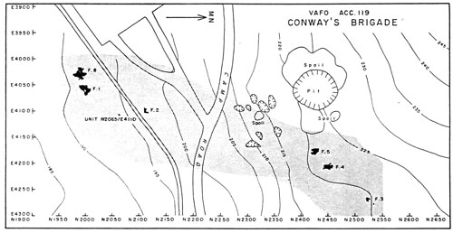
Figure 2. Location of Excavated Features and Site Limit of Conway's Brigade Ten features belonging to the encampment component were identified during excavations: three hut structures, two small trash pits, and two larger trash pits were discovered in the southern portions of the site, located in the open field; and two hut structures and an isolated hearth or firepit were discovered in the northern wooded portion. Four of the structures and all of the trash pits were completely exposed at the base of the plow zone. One large trash pit, two smaller trash pits, and one of the structures in the open field were selected for excavation. The features at Conway's Brigade site appeared to belong to three separate clusters, which may reflect military organization. Comparative analysis focused on the two clusters of hut structures and their immediate areas. Artifacts recovered from and near the structures were typical encampment component items: calcined bone fragments, musket balls and lead sprue (lead lost while casting musket balls), nails, domestic earthenware pottery, and a small quantity of imported non-utilitarian ceramics, bottle and vessel glass, gun flints and flakes, and buttons. In all categories, the quantities and weights were small. Comparison of the distribution of artifacts between these two clusters indicate significant differences between those in the northern part of the site and those in the south. The structures in the northern portion of the site possess significantly less bone refuse (as indicated in the random survey phase), and a complete absence of casting sprue. These differences possibly reflect variation in access to food and supplies. However, decreased levels of these artifacts do not necessarily indicate lower status. Absence of casting sprue may, for example, indicate that completed shot were obtained by the occupants of these structures, indicative of higher status. Moreover, officers of the Continental Army were often served by a communal kitchen which prepared their meals, and probably disposed of the refuse they produced. As a result, fewer bone fragments would be expected around the officers' structures, as compared with those of the enlisted men who prepared and consumed their meals within their own huts. (Later encampments possessed a highly structured layout, based upon rank, with enlisted men forming a front line or lines and the officers located in the rear. Although evidence for a similar organization is indicated for Valley Forge in historic accounts, it has not been verified archaeologically.) The northern cluster of structures is composed of Features 4 and 5 [Figure 3]. Feature 4 possesses a centrally located hearth and a compacted clay floor. The feature measures 16.5 feet on its north/south axis and 9.3 feet on its east/west axis, and is oriented north/south. The hearth measures 6.5 feet by 6 feet, and is defined by a very dark grayish-brown area of solid fired clay mixed with charcoal. This is surrounded on three sides by a zone of brown compacted soil 0.6 to 1.6 feet wide. This zone contains a single square post mold 0.35 feet wide inside a post hole measuring 0.5 feet in diameter. This detail suggests that chimney construction consisted of log cribbing supported by vertical posts. Feature 4 is located on sloping ground, with an elevation change of 0.36 feet over 20 feet from north to south and 1.21 feet over 15 feet from east to west.
Figure 3. Features 4 and 5, with Associated Excavation Units Feature 4 also contained an unusual area, partially exposed, consisting of a linear deposit of fragmented fired clay and extending from the northwest corner of the floor area to the northwest, leading to a slightly thicker area of the same material. Although it is unlikely that this band represents a wall trench filled in with this material after the log sills had been removed, this possibility remains. Feature 5 is another encampment structure, located 25 feet to the southwest of Feature 4. Like its neighbor, Feature 5 appears immediately beneath the surface of the ground. The hearth area measures approximately 5.5 feet by 7 feet, and was defined by a crescentic area of dark brown soil containing fired clay and charcoal. The hearth area is bordered on its east and west margins by a linear area of grayish-brown soil that extends for 13.5 feet on the east and 6.9 feet on the west. The eastern band is oriented a few degrees west of north, while the western band is oriented north/south. Like the other northern features, this feature was not excavated, only exposed. This feature, and possibly Feature 4 to the north, may only represent the northwest corner of a structure which extended into the sloping hillside. The second cluster of structures appears in the open field in the southern portion of the site and consists of Features 1 and 8 [Figure 4]. Feature 1 is roughly rectangular, oriented northeast/ southwest, measuring 19.5 feet by 10.5 feet. It possesses a corner hearth on the northeast. The feature was filled with dark loam containing quantities of sandstone fragments. The hearth area was defined by the presence of baked clay. Because it was only exposed at the base of the plow line and not excavated, internal artifact patterning is only suggestive, by necessity based on distribution in the plow zone directly above the feature. Feature 8 is located approximately fifteen feet southwest of Feature 1. It was defined by an area of brown soil containing charcoal and calcined bone fragments, with a hearth on the south and a pair of small trash pits on its northwest margin. The feature was selectively excavated to reveal the floor profiles and to sample the hearth. The disruption caused by plowing had erased the necessary evidence to determine whether the two trash pits had been located within the structure or immediately outside of it. Since the area excavated for the structure was probably smaller than the exterior dimensions of the structure and since the plowing haserased portions of the first floor, probably reducing its size, there exists only circumstantial evidence that the two pits were located within it. The profiles of the remaining floor area of Feature 8 indicate that only 0.3 feet remain of the original floor. Both trash pits associated with Feature 8 were completely excavated. As both were intact deposits, they provided the best information on the encampment. Both contained primarily faunal material, fired clay, and carbonized wood. The first, which was 2.3 feet by 2.6 feet wide and 1 foot deep, contained tin enameled (Delft) ceramics, pins, an iron disk, and faunal remains. The second pit was somewhat smaller, 2.1 by 1.9 feet wide and 0.8 feet deep. The faunal material recovered from these features consisted primarily of the terminal appendages, and vertebrae of cattle, although some domestic pig (Sus scrofa) was present.
Figure 4. Features 1 and 8, with Associated Excavation Units Feature 8 contained a large post hole, located at the north-central end. Half of the post hole was examined; it was 1.9 feet wide, 1.3 feet deep, and 3.1 feet long, gradually sloping inward. This detail is analagous to those identified at the end of the structure opposite the hearths in previous brigade excavations. The post holes are thought to represent the location of the doorway [Parrington 1979:6]. In conclusion, artifact and feature patterning as revealed by excavation suggests that the internal structure of the brigade area generally conforms to the meager historical record, with clusters of structures that are aligned roughly northeast/southwest along a narrow corridor. There was little evidence, however, to suggest that the structures were organized into groups of twelve, as indicated in the Ewing account. Structure dimensions and construction details, at the same time, do roughly agree with historic documents, especially the Ewing account. TopReferences Cited
Blades, Brook S., David G. Orr, and Douglas V. Campana
Ewing, T. [Editor]
Parrington, Michael |