|
Home : Quarterly Archives : Volume 29 |
Tredyffrin Easttown Historical Society |
|
Source: October 1991 Volume 29 Number 4, Pages 141–150 The Early Development of Devon Following the successful development of Bryn Mawr in the 1870s by the Pennsylvania Railroad, similar developments were started farther to the west along the Main Line. Towards the end of the decade Lemuel Coffin and Joseph B. Altemus, dry goods commission merchants in Philadelphia, decided to undertake the development of the area in the vicinity of the recently erected railroad station named Devon. In August 1881 they purchased several farms in the area, including the large farm of Lewis Davis, and put together a tract of more than 300 acres south of the Lancaster Turnpike and west of Valley Forge Road [also sometimes known as the Welsh Line or County Line Road]. Shortly afterwards they announced their plan to build a town of "large and handsome country residences" on the site. The development and growth of this town, named after the railroad station, is reflected in the various atlases "of properties along the line of the Pennsylvania Railroad", the so-called "railroad atlases", published from time to time, first by G. M. Hopkins, then by J. L. Smith, and later by A. H. Mueller and Company. On the following pages are reproduced from several of these atlases the parts of the maps that show Devon. The maps have been reduced in size, and in some cases parts of several maps have been pieced together. In a few instances the name of a property owner has also been repositioned so that it is included on the part of the map that has been reproduced. A comparison of each map with the one preceding it or the one following it shows graphically the changes that took place as Devon developed and grew in the late 19th and early 20th century. Top1881 This map is made up from two maps in the 1881 atlas, and shows the location of the Coffin & Altemus tract, astride Waterloo Road southwest of the Devon railroad station. The railroad station in Devon, as shown on this map, was originally about a quarter of a mile to the east of its present location, on the east side of Valley Forge Road and actually in Tredyffrin Township. At that time the road went over the railroad on an overpass; while the bridge is no longer used as a bridge it is still used to support the railroad signals. The small settlement in the vicinity of this new station consisted, for the most part, of about a dozen homes along the Lancaster Turnpike [now known as Old Lancaster Road] north of the railroad. South of the railroad the land was mostly farmland or open space. There were only a few roads. North of the Turnpike was the road known a century ago as Old Lancaster Road [now known as Conestoga Road]. To the south was another east-west road, the present Sugartown Road, identified on one map by that name, but shown on the other as Eagle Road, presumably because, if traveled from west to east, it led to the vicinity of the Spread Eagle Inn. At the bottom of the map is Church Road, which went to the east to St. David's Church. Running north and south, in addition to Valley Forge Road, was Waterloo Road, which led south to Waterloo Mills, on Darby Creek. (Although they are not relevant to the development of Devon, there are several other items of interest on this map. First, two of Easttown's three public schools at that time are shown: the Glassley School, in the upper left hand corner of the map, on the south side of the Turnpike; and the Ogden School, at the bottom of the map near the center, just north of Church Road. And in the upper right hand corner of the map is shown apart of J. Langdon Wentworth's estate "Strafford", for which another new railroad station built a few years later to replace the old Eagle station was named.)
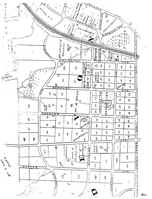
Top 1887 By 1887 Coffin & Altemus had added the adjoining 150-acre property that had been owned by Henry J. Pleasants Jr. to their tract, as shown on this map from the atlas of that year; constructed several roads on the property; and "laid out" their planned town into lots of two-and-a-half to five acres each. They had also erected the handsome Devon Inn, and had already induced about a dozen or so prominent Philadelphia families to build homes or summer places in the new town. A new railroad station had also been built by the Pennsylvania Railroad, west of the site of the first station, on the east side of Waterloo Avenue. A new post office had also been established, in the station, with William Lewis Reed, the station master, also the postmaster. The Devon Inn, the L-shaped building near the center of the map, was "a large hotel similar in its appointments to the one at Bryn Mawr" that had been built by the Railroad as an important part of the development of that area. The Inn at Devon opened in August 1882, and when it was destroyed by fire the following year it was immediately replaced with an even larger and grander hotel. It not only provided facilities for a fine summer resort, but also helped acquaint its guests with the advantages and convenience of summer and year-round residence in the area. A waterworks and ice house, shown at the left on the map, were constructed to provide water and ice. The new 50-feet wide streets in Devon running east and west were Arlington [now a section of Lancaster Avenue], Berkley [not Berkeley], Chester, and Exeter avenues: their names were taken from English places or persons, in keeping and compatible with the English name given to the railroad station. (Sugartown Road was also renamed Devon Avenue, giving the east-west streets an A-B-C-D-E alphabetical sequence, but the new name was never really accepted.) Also running east and west, between the railroad and the Turnpike, was another new street, named Highland Avenue. The new north-south streets were Dorset and Fairfield avenues, on either side of Waterloo Avenue. Fairfield Avenue crossed the railroad at a grade crossing. It is also interesting to note that the property of James C. Brooks, north of the railroad and east of the station, is shown on the map as woodlands, while much of the land to the west of Fairfield Avenue, where the icehouse and pond were located, was mostly woods and swamp land.
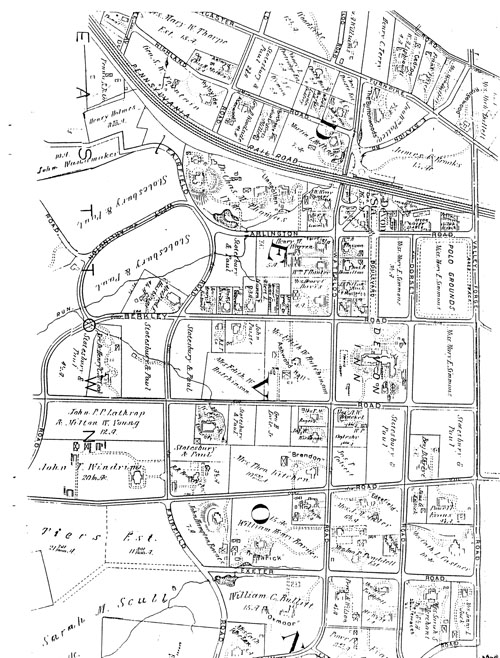
Top 1897 This is a map of Devon ten years later, from the 1897 atlas. By 1897 a boulevard [now Devon Boulevard] had been built between the Devon Inn and the railroad station, bordered by trees on either side. Omnibuses met all trains to convey guests to the Inn. The grounds of the Devon Inn had also been expanded, to include the entire square bounded by Berkley, Dorset, Chester, and Waterloo avenues. The eight lots in the square northeast of the Devon Inn were now identified as a Polo Ground [now the Devon Horse Show Grounds], with a racetrack running around its perimeter. Beginning the following year, it became the home of the Devon Horse Show. Across Arlington Avenue was the livery stable of Dennis Sullivan, where a variety of carriages and other vehicles, as well as horses, were available for the convenience of guests of the Inn. By now there were almost forty homes in the town as its growth continued, particularly along Waterloo and Berkley avenues, and along Dorset Avenue south of Devon Avenue/Sugartown Road. With the larger estates to the south and southwest, not shown on the map, as the new century approached Devon was becoming a fair-sized town. Among the newcomers, incidentally, was George H. Earle Jr., who purchased the William B. Mann property across from the Devon Inn, naming it "Shady Crest". (It was here that George H. Earle III, later governor of Pennsylvania, was born in 1890.) Similarly, Dr. John Packard's estate "Tregarick" was now the estate of William Henry Barnes. The Presbyterian Church, St. John's, organized in 1892, is also shown, on the north side of Berkley Avenue west of Waterloo Avenue, with a schoolhouse adjacent to it on the west. During the decade since 1887 additional lots were also laid out, as shown on the map, west of Fairfield Avenue.
Top 1908 This map, from the 1908 atlas, shows Devon a decade later. During this decade both Arlington and Berkley roads -- for some reason the streets south of the Turnpike were now designated as roads rather than as avenues - were extended beyond Fairfield Road, in curves so that they intersected with the road to the south of them. Thus Arlington Road -- its extension was known as West Arlington Road [but is now known simply as Arlington Road] -- continued west and then south to Berkley Road, and Berkley Road similarly was extended west and then south, across Chester Road and down to Devon/Sugartown Road. The grade crossing of Fairfield Road across the railroad was also eliminated. The original Coffin & Altemus tract in the vicinity of the station was virtually fully occupied with homes in 1908 as Devon continued to grow to both the south and the west. (In fact, the map in the 1913 atlas, five years later, shows very little change from this map; aside from a few property transfers during those five years the two maps are almost identical.) Among the new estates was William C. Bullitt's 15-acre "Oxmoor", south of Exeter Road and west of Waterloo Road. (One of his son's, William Jr., was the first ambassador to the Soviet after it was recognized in 1933, while another, Orville, was one of the founders of the local Blue Cross and chairman of the board of the Philadelphia Orchestra.) A parcel of land, shown in the upper left hand corner of the map, had apparently been bought by John C. Wanamaker, though it does not appear that he ever built on it. The Earle estate was now owned by Mrs. Edith W. Hutchinson, who renamed it "Ashwood Hall". The school adjacent to St. John's Presbyterian Church was identified as Miss Emma R. Harrar's Devon School. The few properties that were still undeveloped, incidentally, were now the property of Stotesbury & Paul or of Miss Mary Simmons, who, with her sister, was the manager of the Devon Inn. It is also interesting that apparently Devon could support three livery stables, all located between Arlington Road and the railroad. A police headquarters had also been established in the triangle between Arlington Raod and the railroad, west of the Boulevard. Devon was by now the town of "large and handsome country residences" -- many of them are still standing -- that Lemuel Coffin and Joseph Altemus had envisioned a little more than a quarter of century earlier.
Top Sources of Maps 1881: Atlas of Bryn Mawr and Vicinity or of Properties Along the Pennsylvania R. R. Including 1-1/2 miles each way of the Road From City Line to Malvern Station From Official Records, Private Plans, and Actual Surveys Published by G. M. Hopkins, C. E.320 Walnut Street, Philadelphia 1881 1887: Atlas of Properties Along the Pennsylvania R. R. Embracing Two Miles Each Side of the Railroad and From Overbrook to Malvern Station Compiled From Official Records, Private Plans, and Actual Surveys by G. W. Baist, Topographical Engineer Published by J. L. Smith 27 South Sixth Street, Philadelphia, Pa. 1897: Atlas of Properties on Line of Pennsylvania R. R. From Rosemont to West Chester Compiled and Drawn from Official Plans and Actual Surveys by Ellis Kiser, Otto Barthal & St. J. Ogier, Civil Engineers Published by A. H. Mueller and Co.530 Locust Street, Philadelphia 1897 1908: Atlas of Properties on Main Line Pennsylvania Railroad From Overbrook to Paoli Compiled from Actual Surveys, Official Records and Private Plans by Ellis Kiser, C. E. Under the Direct Management and Supervision of A. H. Mueller, Publisher 530 Locust Street, Philadelphia, Pa. 1908 1913: Atlas of Properties on Main Line Pennsylvania Railroad From Overbrook to Paoli Compiled from Actual Surveys, Official Records and Private Plans by Ellis Kiser and J. M. Lathorp, Civil Engineers Under the Direct Supervision and Management of A. H. Mueller, Publisher 530 Locust Street, Philadelphia, Pa. 1913 Edition [Not reproduced] TopSee also:
When the Pennsylvania Railroad Promoted Suburban Living
Devon Inn
History on a Sign Post |